பெரியார் பல்கலைக்கழகம்
அரசு பல்கலைக்கழகம், சேலம்.
PERIYAR UNIVERSITY
State University - NAAC 'A++' Grade - NIRF Rank 94
State Public University Rank 40 - SDG Institutions Rank Band: 11-50
Salem - 636 011, Tamil Nadu, India.

CENTRE FOR GEOINFORMATICS AND PLANETARY STUDIES
ABOUT THE DEPARTMENT
About the Centre The Centre for Geoinformatics and Planetary Studies was established in 2010, with an objective of conducting advanced research and promote higher education in the field of Remote Sensing, GIS and Planetary Studies. The centre has basic infrastructure and computational facilities for Remote Sensing, Digital Image processing and GIS work. The research activities in the centre are in the fields of planetary remote sensing, hyperspectral remote sensing and mineral exploration, disaster mapping and mitigation, sustainable ground water development and climate change in water resource. The centre has received Rs.1.27 crore worth of major research projects from various funding agencies. The centre has produced and supplied Lunar soil simulant to ISRO for creation of terrain testing facilities for Chandrayan Missions.
Vision
The Centre for Geoinformatics and Planetary Studies was established in attainment of national and international recognition through quality teaching, innovative research, consultancy, manpower training and service to the society.
Mission
PROGRAMMES OFFERED
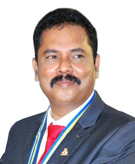
DIRECTOR

DR. R. VENKATACHALAPATHY
Professor and DirectorRESEARCH TEAM
| S.No. | NAME |
TOPIC |
CONTACT DETAILS |
|---|---|---|---|
| 1 | Dr. A. Jothibasu, UGC Post Doctoral Fellow | Impact of Climate Change on Groundwater Aquifers | Email : ajbasu.a09@gmail.comMobile : +91 9940886565 |
| 2 | Dr. S. Uma Maheswaran, (SAC-ISRO funded project) Research Associate | AVIRIS NG airborne data for Lithological Mapping | Email : umamahes05@gmail.comMobile : +91 9894342121 |
| 3 | Mr. K. Tamilarasan, SRF (DST funded project) | Hyperspectral Remote Sensing study of Mafic/Ultramafic rocks | Email : ktamilarasan05@gmail.comMobile : +91 9788911047 |
| 4 | Mr. E. Manikandan, URF | Groundwater contamination due to urban pollution | Email : emanigeo@gmail.comMobile : +91 984359446 |
| 5 | Ms. G. Kavitha, DST-INSPIRE Fellow | Landslide studies of Vathalmalai | Email : gkavitha782@gmail.comMobile : +91 9578954815 |
| 6 | Mr. A.T. Gowthaman, SRF (SAC-ISRO funded project) | Morphological and Lithological Mapping of Lunar Basins | Email : gowthamt@gmail.com Mobile : +91 9600257413 |
| 7 | Mr. S. Ranjith Kumar, SRF (DST funded project) | Hyperspectral Remote Sensing of study of carbonatite and Alkaline rocks | Email : georanjith1993@gmail.comMobile : +91 9688446937 |
| 8 | Mr. L. Suresh (P/T) | Remote Sensing study of commercial granites | Email : Mobile : |
| 9 | Mr. S. Ramamoorthi (P/T) | Earthquake Prediction through deep Earth Electrical Charge flow detector and Gravity Anomaly | Email : Mobile : |
| 10 | Mr. O. Ilamurugan (P/T) | Ground water contamination studies along Cauvery River | Email : Mobile : |
FACILITIES
OUTREACH PROGRAMMES
- ISRO – IIRS 25nd Outreach Programme on “Hyperspectral Remote Sensing” September 18- 21, 2017 at Centre for Geoinformatics and Planetary studies, Periyar University, Salem.
- ISRO – IIRS 24nd Outreach Programme on “Remote Sensing and Digital Image Analysis” August 21 - September 15, 2017 at Centre for Geoinformatics and Planetary studies, Periyar University, Salem.
- ISRO – IIRS 23rd Outreach Programme on “Basics of Remote Sensing, Geographical Information System and Global Navigation Satellite System” August 21 –December 01, 2017.
- ISRO – IIRS 22nd Outreach Programme on “UAV Remote Sensing and Applications” July 03-07 2017 at Centre for Geoinformatics and Planetary studies, Periyar University, Salem.
- ISRO – IIRS 19th Outreach Programme on "Remote Sensing and GIS Applications in Carbon Forestry" February 16 – March 10, 2017 at Centre for Geoinformatics and Planetary studies, Periyar University, Salem.
- ISRO – IIRS 18th Outreach Programme on "Basics of Remote Sensing, GIS & GNSS" August 22 – November 18, 2016 at Centre for Geoinformatics and Planetary studies, Periyar University, Salem.
- ISRO – IIRS 17th Outreach Programme on "Geoweb Services and Geoportal applications” June 28 - July 15, 2016 at Centre for Geoinformatics and Planetary studies, Periyar University, Salem.
- ISRO – IIRS 16th Outreach Programme on "Geospatial Technologies for Urban Planning" February 11 - March 15, 2016 at Centre for Geoinformatics and Planetary studies, Periyar University, Salem.
- ISRO – IIRS 15th Outreach Programme on "Basics of Remote Sensing , GIS & GNSS" August 10 – November 27, 2015 at Centre for Geoinformatics and Planetary studies, Periyar University, Salem.
- ISRO – IIRS 14th Outreach Programme on "Applications of Remote Sensing and Geographical Information System For Natural Resources" January 27 – March 27, 2015 at Centre for Geoinformatics and Planetary studies, Periyar University, Salem.
- ISRO – IIRS 13th Satellite based Distance Learning Program on "Basics of RS, GIS & GNSS" conducted during August 04 – November 14, 2014 at Centre for Geoinformatics and Planetary studies, Periyar University, Salem.
- ISRO – IIRS 12th Satellite based Distance Learning Program on "Microwave (SAR) Remote Sensing for Natural Resources" conducted during February 03 – March 29, 2014 at Centre for Geoinformatics and Planetary studies, Periyar University, Salem.
SEMINAR / WORKSHOP ORGANIZED
- National Workshop on ‘‘Advances in Geoinformatics’’ 11th to 12th January 2016, Centre for Geoinformatics and Planetary studies (CGIPS), Periyar University, Salem.
- Workshop on Bhuvan – Panchayat Portal and Mobile Application for Asset mapping an ISRO Internet based distance learning programme during 27th July 2016 at Centre for Geoinformatics and Planetary studies, Periyar University, Salem.
- Workshop on “Advanced Remote Sensing & GIS Technology for Earth Scientist” January 6th 2015, Centre for Geoinformatics & Planetary Studies and Sakura Geoinformation Software Research, Jointly organized.
- Special Lecture on ‘Near Surface Processes in MARS- A Mineralogical Perspective’ during 2nd December 2013 at Periyar University, Salem.
FUNDED PROJECTS
AGENCY |
PROJECT TITLE |
PERIOD |
AMOUNT / STATUS |
|---|---|---|---|
| DST | Geological, Geomorphological and Geotechnical studies for Landslide Assessment along Ghat road of Kolli Hills (Project- “Kolli landslide”) | 2010-2012 | Rs.12,59,000 / Completed |
| PRL-ISRO PLANEX Programme | Reflectance Spectra and Petrological studies of Kadavur structure - a possible Terrestrial analog for Lunar Highland Region (Project “RESPET Kadavur”) | 2012-2015 | Rs.26,68,560 / Completed |
| DST | Hyperspectral Remote sensing Study in Lithological Mapping of Alkaline Complex Terrain & Reflectance Spectral Study of Platinum Group of Elements (Project “HyperLiM”) | 2016-2020 | Rs.34,44,500 / Ongoing |
| SAC-ISRO | Geomorphic process and Morphometric analysis of Cusus | 2016-2020 | Rs.17,85,840 / Ongoing |
ALUMINI
| Dr. S.Arivazhagan, Assistant Professor, Centre for Applied Geology, Gandhigram Deemed University, Gandhigram - 624 302, Dindigul District, Email : arivusv@gmail.com, Mobile: 9994520251 |
| Dr. A. Jothibasu, UGC Post Doctoral Fellow, Centre for Geoinformatics and Planetary Studies, Periyar University, Salem- 636011, Email : ajbasu.a09@gmail.com, Mobile: 9940886565. |
| Dr. C.K.MuthumaniRaja, Assistant Director (Retd), Ground water Geological sub-division, Erode : 638 002. |
| Dr. A. Venkatesan, Assistant Professor, Periyar University College of arts and Science, Mettur – 01, Mobile : 9150006833. |
| Dr. M. Rajendran, Assistant Director, Ground water Geological sub-division, Chennai. |
| Dr. V. Ramesh, Assistant Professor, Jamsetji Tata School of Disaster Studies, Tata Institute of Social Sciences, V.N. Purav Marg, Deonar, Mumbai - 400088, Email: rameshremote@gmail.com, Mobile : 994419122. |
| Dr. C.R. Paramasivam, Guest Lecturer, Department of Remote Sensing, Bharathidasan University, Thiruchirappalli, Email: pusivam@gmail.com, Mobile : 9578546095. |
PHOTO GALLERY
CONTACT
DR. R. VENKATACHALAPATHY,
Professor & Director, Centre for Geoinformatics and Planetary Studies (CGIPS), Science block II, Periyar University, Periyar Palkalai Nagar, Salem – 636 011, Tamil Nadu, India © Periyar University - 2022. All Rights Reserved.
Developed & Maintaining by Computer Centre
